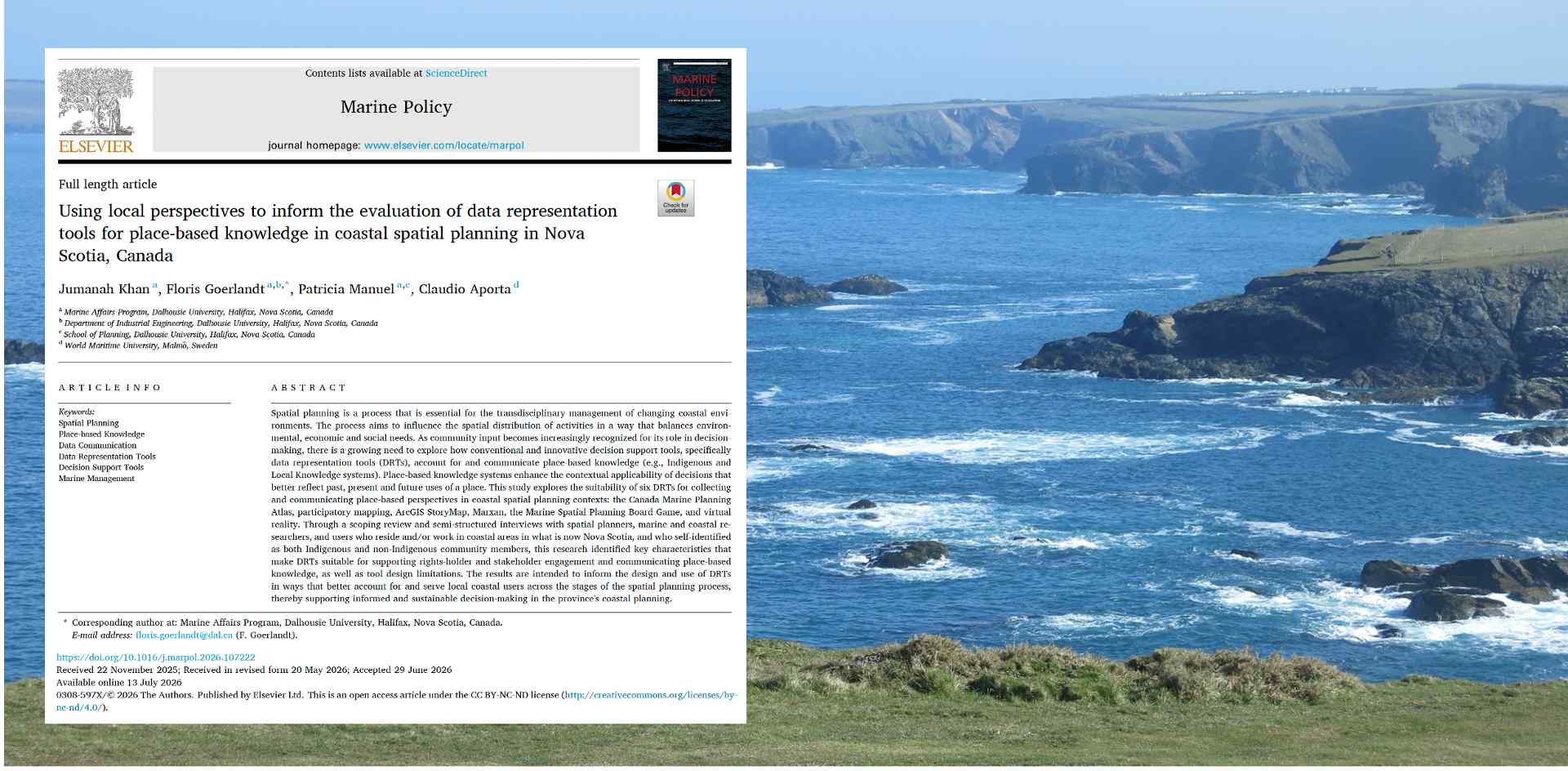
Spatial planning, or the allocation of activities in a given area, is an important function of coastal management. Especially given that demand for space in coastal areas can be in conflict. Decisions made about spatial planning often begin with maps, models, and datasets. But these methods can miss the relationships, uses, histories, cultural and spiritual meanings, and temporal changes that make a place what it is.
With so many different activities existing at various geographic and temporal scales, there is a need for informed, site-specific spatial planning. Khan et al. (2026) asked and explored how planning tools can better represent the knowledge of people who live in, work in, steward, and maintain relationships with coastal environments in Mi’kma’ki, in what is now known as Nova Scotia.
Why place-based knowledge matters
Place-based knowledge is knowledge that develops through long-term, often intergenerational relationships with a particular environment. It may include observations, memories, stories, cultural practices, livelihoods, seasonal patterns, and understandings of how people, species, land, and water are connected. Examples include Indigenous and local knowledge systems.
This knowledge is place-specific and cannot always be captured by standardized datasets or mapped boundaries alone. In coastal planning, such knowledge can reveal how environments have and continue to change over time, which places hold cultural and ecological significance, and how proposed decisions may affect community well-being, livelihoods, and surrounding ecologies.
Nova Scotia’s coastal areas are home to approximately 70% of the province’s population and are continually shaped by culture, climate change, and diverse and at times competing uses. However, conventional approaches to spatial planning decisions rely primarily on generalized or quantitative information and can ignore important place-based realities. One participant of the study reflected:
They [decision-makers] manage fish and don’t even know what the fish looks like, or they haven’t even touched or handled the fish. I mean, they often don’t have any connection to what they are making decisions about, and they often say to me, you’re too connected. But that’s the problem – they need to be connected too to make realistic decisions.
This participant of the study continued by highlighting the value of lived experience, observational knowledge, and combining knowledge systems in decision-making, sharing that:
We [residents and local knowledge holders] can read all the academic papers. We can look at everything that everybody can see, but we also live it. We also see it. It’s imprinted in our brains.
Quotations like these shared insights into how place-based knowledge practically informs and enriches data. It is this knowledge that ought to be better represented in the tools used to collect and communicate data used in decision-making related to spatial planning.
Data representation tools
Data representation tools (DRTs) are a type of decision-support tool that focus on the visual representation of data through software applications or activities that convey complex scientific or statistical information in a comprehensible way. In their design and functionality, several DRTs aim to integrate contextual knowledge and principles of visual perception to enhance the communication of scientific data. Because data representation tools are typically designed using Western frameworks that emphasize quantification and abstraction, they may not effectively capture and convey the richness of place-based insights–often based in cultural context, embodied knowledge, and storytelling–without proper design considerations.
The study sought to explore and evaluate the usefulness of six DRTs in accounting for and communicating, i.e., representing. place-based knowledge, in a spatial planning context. These tools were: the Canada Marine Planning Atlas, participatory mapping, ArcGIS StoryMap, Marxan, the Marine Spatial Planning Challenge board game, and virtual reality.
These tools were selected because of their current or potential use in coastal spatial planning in the province. They were also chosen as they align with Canada’s Ocean Act, which emphasizes integrating ecological, economic, cultural, and social objectives into decision-making processes, and they have the capacity to use and combine visualization techniques and contextual knowledge.
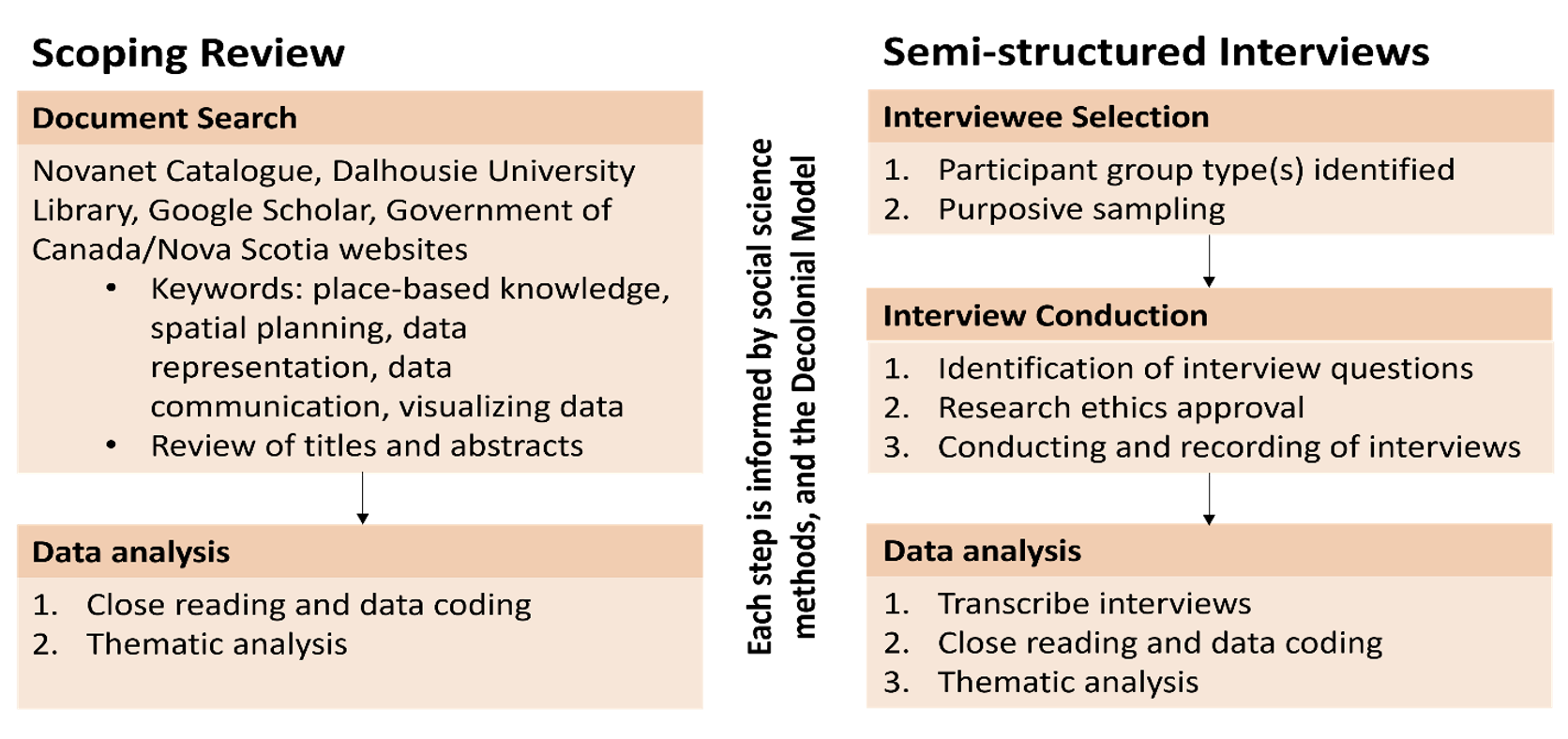
The evaluation of these tools and their ability was conducted using a scoping review and semi-structured interviews with 10 coastal users, researchers, and planners in Nova Scotia. The methods used in the study are summarized in the figure below:
What makes a tool useful?
The participants reviewed the selection of DRTs and characterized their views on their functionality by offering descriptions of what makes them useful in representing place-based knowledge: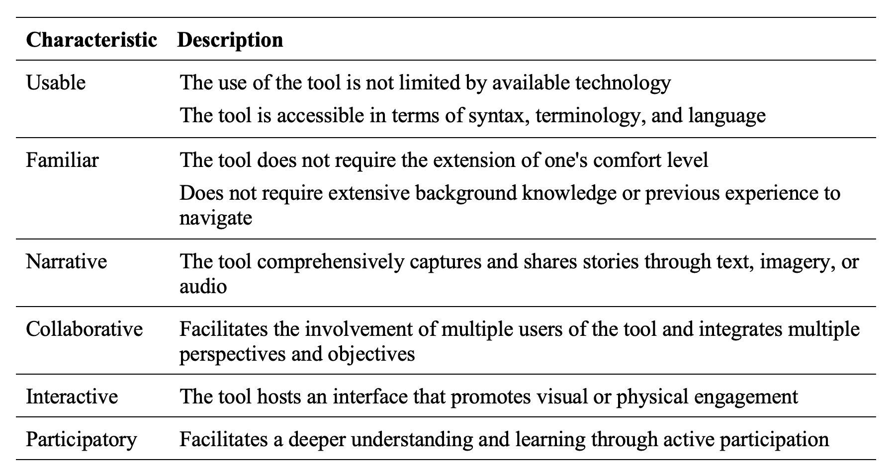
The participants didn’t indicate, however, that the identified “useful” characteristics apply to all DRTs included in this study. Instead, the participants’ answers suggested all tools could benefit from a user-informed design. The most suitable choice depends on the purpose of the tool, its intended users, the stage of planning, and the knowledge systems to be represented.
Seeing the Symphony
A central concern raised by participants was that conventional approaches can fragment complex coastal relationships into isolated data points, distancing–or in some cases, removing–data from their original meaning. One participant explained:
They’ve only plucked out the things that they want, but there’s a lot more in there…I mean, for me, I was trying to show them the Symphony, and they’re still picking out little pieces to make clear.
This “Symphony” captures the interconnected ecological and social relationships that unfold along the coasts of Nova Scotia over time. A single point on a map may identify a location, but it may not convey its cultural significance, seasonal importance, history, or relationships with surrounding species and activities.
Storytelling can help communicate that broader context. Another participant described how stories associated with Glooscap’s journey through the Bras d’Or Lakes carry knowledge about landmarks and navigation:
If you know this story…you should be able to navigate waters–without a map or anything–just by the markers on the land.
In this context, stories of place are not to be understood or used as additions to quantitatively derived technical information; they themselves can be a source of ecological, cultural, historical, and practical information.
Designing tools with communities
Improving data representation requires changing how tools are designed, governed, and used. Therein lies an opportunity for a transformation in how place-based knowledge is viewed, understood, involved, and represented in spatial planning in the province.
Communities and knowledge holders should be involved meaningfully in deciding what information is collected, how it is represented, who can access it, and how it informs decisions. This approach is particularly important when working with Indigenous knowledge, where principles of consent, cultural protocols, data governance, and Indigenous data sovereignty must be adhered to.
Existing data representation methods can be adapted by transforming and reimagining techniques and tools through a decolonizing lens that accounts for local and Indigenous knowledge systems and worldviews. This tool adaptation could be further developed by designing DRTs that incorporate local narratives, in addition to spatial and/or quantitative information. For example, the Naonaiyaotit Traditional Knowledge Project Atlas, a collaboration between Kitikmeot Inuit Association, Dominion Diamond Mines, ESRI Canada, and the Marine Affairs Program at Dalhousie University, demonstrates how local stories and Inuit knowledge can be integrated into digital mapping tools to advance the contextual understanding of an area.
A combined approach
The study’s central conclusion is that there is no one-size-fits-all tool for representing place-based knowledge. Different tools may be useful at different points of planning:
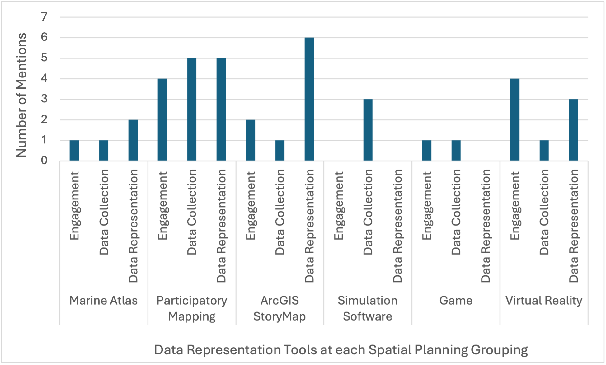
- Participatory mapping can support engagement and knowledge collection.
- StoryMaps can communicate local histories, narratives, and relationships.
- Marine atlases can organize spatial information.
- Games can help rightsholders and stakeholders explore trade-offs and negotiation.
- Virtual reality can support the visualization of spatial changes and their impacts.
- Simulation tools can support technical scenario development when used carefully and transparently.
As indicated by the study participants–users, researchers, and planners–there is potential to apply multiple DRTs in conjunction to provide a richer representation of place-based knowledge across spatial planning groupings. Perhaps there is an opportunity to design or adapt a tool that incorporates the characteristics identified by participant groups.
The goal of exploring how planning tools can better represent place-based knowledge is to support spatial planning processes that respect diverse ways of knowing and to bring relevant, often underrepresented knowledge to the forefront of decision-making. When planning tools can communicate not only where activities occur, but also why places matter and how relationships change over time, they can support decisions that are more inclusive, contextually relevant, and trusted by coastal communities.
Reference
Khan, J., Goerlandt, F., Manuel, P., & Aporta, C. (2026). Using local perspectives to inform the evaluation of data representation tools for place-based knowledge in coastal spatial planning in Nova Scotia, Canada. Marine Policy, 193. https://doi.org/10.1016/j.marpol.2026.107222
Author: Jumanah Khan
 Jumanah holds a Masters degree from the Marine Affairs program at Dalhousie University, where she contributed to the Ocean Frontier Institute’s Benthic Ecosystem Mapping & Engagement (BEcoME) project and explored how place-based knowledge can inform coastal spatial planning in Nova Scotia. She is now a PhD candidate at the University of Iceland’s Faculty of Life and Environmental Sciences, where her research investigates the intersections between neoliberalism, protected areas, and people in Arctic and subarctic coastal regions.
Image: The photograph of a coastal setting is provided thanks to Peter G. Wells.
Tags: Information Use & Influence; Marine & Ocean Issues, Public Policy & Decision-Making; Scientific Communication