Marine spatial planning (MSP) is being implemented in a growing number of countries globally. The Canadian federal government, through the Department of Fisheries and Oceans (DFO), is in the midst of marine spatial planning for five marine planning areas in Canadian waters, including three in Atlantic Canada. The first product in this planning initiative is the online Canada Marine Planning Atlas (an Atlantic atlas, and a Pacific atlas), which was launched in February 2023. Land use and community planners in Canada’s coastal regions can contribute knowledge and expertise to MSP, but many are unaware that it is happening, let alone what it is. Members of the Dalhousie University-based Marine Spatial Planning research group in the Social License and Planning for Coastal Communities module of the Ocean Frontier Institute, together with participation from DFO Maritimes Region, helped to shed some light on MSP and the Canadian program for the benefit of planners attending the Atlantic Planners Institute (API) Conference in Charlottetown, Prince Edward Island, 19-21 October 2022.
The Atlantic Planners Institute comprises professional planners from the four Canadian Atlantic Provinces. Members of the Institute meet annually to explore contemporary topics in planning and share experiences and advances in planning practice and research in the region. The 2022 conference theme, “A place for everyone,” focussed on inclusion, broadly defined, and covered housing; transportation; immigration, diversity, equity and inclusion; reconciliation; and climate change. Marine planning might have seemed a thematic outlier at first glance, but close to 40 participants attended an early Friday morning session to learn about “A place for communities in marine spatial planning.” In addition to this session, members of the MSP research group presented three posters describing our research in the conference poster exhibit (see below).
Coastal communities have much to gain from MSP and will be impacted by planning and development activities that involve shore-based infrastructure, coastal economies and ways of life, and the cultural relationship with the sea. These topics are subjects of community planning in coastal regions. Community and land use planning and marine planning meet at the shore, but the implications of both extend beyond their respective boundaries. Through the oral presentation session and posters, we introduced marine spatial planning and the Canadian program, examined linkages between land and sea that are shared topics of interest in marine and terrestrial planning, identified local community interests of relevance for a digital marine atlas, and considered roles for coastal communities in MSP.
Conference Session
Dr. Patricia Manuel, Dalhousie University School of Planning, and co-lead of the MSP research group, chaired the session, which included four speakers. She introduced the relevance of MSP for coastal communities and facilitated the discussion of what land use and community planners can contribute to and how they can engage with the MSP processes.
Jason Naug, Department of Fisheries and Oceans, Maritimes Region, spoke about the DFO Maritimes Region marine spatial planning program. A planner, biologist, and environmental specialist, Mr. Naug has played lead roles in ocean and coastal management initiatives, particularly in the Bras d’Or Lakes and Bay of Fundy, and currently leads the development of a marine spatial plan for the Scotian Shelf / Bay of Fundy planning region. He provided an overview of Marine Spatial Planning and of Canada’s MSP initiative. He explained that Canada’s “coastal and ocean waters are busy places where traditional activities such as fishing and shipping share space with oil and gas development, recreation and tourism, submarine cables, aquaculture, renewable energy, nature conservation, and others. These activities may conflict with each other in time and space and impact the marine environment. Marine spatial planning is one way to better understand and consider these activities together in order to minimize conflicts and meet common objectives.”
Jason noted that MSP is another aspect of DFO’s engagement in marine management, which started over 20 years earlier with Integrated Coastal and Ocean Management, under the national Oceans Act. MSP is now underway in the Pacific and Atlantic marine regions with a goal to complete first generation regional MS plans by March 2024. The Canadian MSP program focuses on using existing or establishing new governance structures to support MS planning; an online marine atlas of key features, sensitivities, and activities of the marine environment; developing decision-support tools for improved analysis to inform decision-making; and bioregional marine spatial plans.
Specifically, management frameworks will be developed for each of the bioregional marine spatial plans. Each plan will include a context document and a framework document. The context document will present an overview of the planning areas; key outcomes and goals; lessons learned from previous planning exercises (for example, the Eastern Scotian Shelf Integrated Management initiative); the legal status of the plan; and linkages with other initiatives (such as Marine Protected Area planning). The framework document will describe the current interests and priorities of the planning partners, the work necessary to advance those priorities, and a process for evaluating progress. Future iterations in the planning process will require stakeholder engagement. Subsequent versions of the plans may address spatial allocations as appropriate but cannot be regulatory under DFO because the department does not have legislative authority under the Oceans Act to regulate all users in a spatial manner. As a result, the development of marine zoning plans, which define where various activities can take place and are generally associated with MSP globally, are not feasible under DFO’s current legislative mandate. MSP in Canada, at least nationally, is strategic policy and planning oriented.
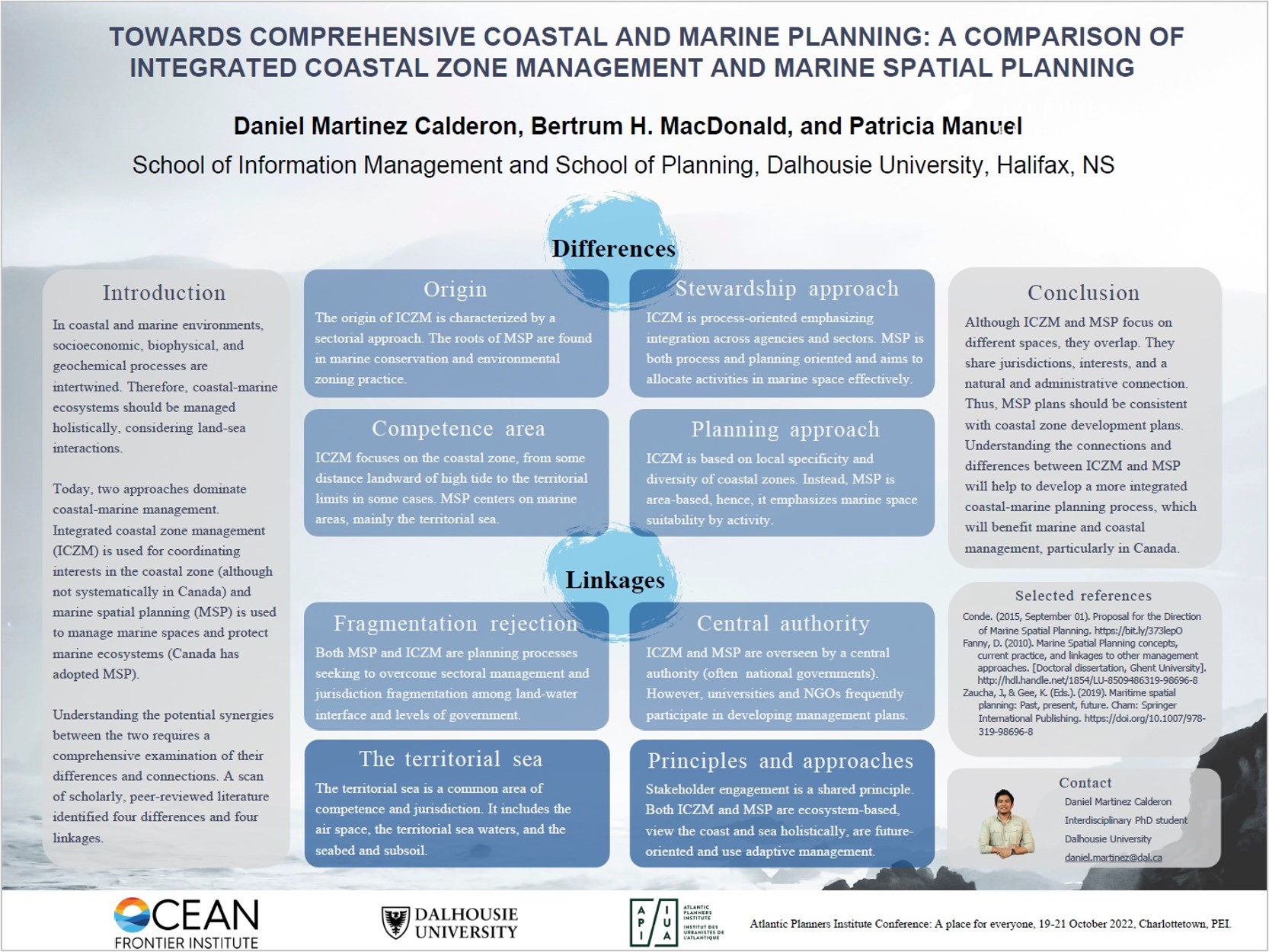
Daniel Martinez Calderon, an Interdisciplinary PhD student at Dalhousie University, presented the paper “Connecting land and sea – crossing the planning and governance divides” (coauthored with Patricia Manuel and Bertrum MacDonald). In his doctoral research he is developing a framework for participatory, place-based marine spatial planning in Atlantic Canada. Daniel holds degrees in coastal management and has consulted for NGOs on sustainable fishing, participatory planning, participatory mapping, and community coastal development. His presentation in this session and his poster (see below) examined the connections between land and marine planning and planning approaches that co-exist in the coastal marine zone. Land and marine planning should be holistic and integrated since socioeconomic and biogeochemical interactions connect terrestrial and aquatic ecosystems. Terrestrial Spatial Planning (TSP), Integrated Coastal Zone Management (ICZM), and Marine Spatial Planning are approaches to plan land and marine areas, but they should not be exclusive and operate independent of one another. Some differences between these approaches include the focus of practice (land, coast, sea), the orientation of the approaches, and property rights. Similarities include flexibility of the processes, common purposes, and the principle of stakeholder engagement. Ecosystem-based management and Indigenous governance can be an inspiration to connect land and marine planning as both promote a holistic view of the world. Other options include extending local and regional land planning into the marine space (at least by recognizing land use impacts on marine environments), creating a national strategy that encompasses both environments across the coastal zone, and extending the MSP remit inland. Of the three planning systems, two dominate coastal-marine management: ICZM (although not in Canada), and MSP.
Julia Szujo, a Master of Planning student at Dalhousie University, presented the paper, “Atlantic Canada marine atlas: An opportunity for communities to become engaged in MSP,” which was based on research she completed within the Marine Spatial Planning research group. She spoke about the first product of the Canadian MSP process, namely, the Canada Marine Planning Atlas-Atlantic, an online, interactive atlas displaying spatial data of interest to marine resource use and environmental protection. Coastal communities are closely connected to the ocean and should benefit from MSP. The Atlas can inform members of these communities about relevant legislation and spatial data and the Atlas could also be an excellent tool to facilitate local engagement in MSP processes. Using a combination of analysis of marine atlases in select jurisdictions globally and exploration of the Atlantic Atlas with coastal stakeholders in Nova Scotia, this research identified how the data in the Atlas are relevant and useful for local-level interests and how incorporating finer scale data could strengthen the utility of the Atlas for planners and decision makers in coastal regions in the province. Increasing opportunities for local-level users to participate in MSP can enhance the relevance of marine plans. Highlights of this research showed that a public atlas needs to be accessible for users with diverse interests and needs; the Atlantic Atlas can be a tool for community education and engagement in MSP; the Atlas has potential uses in local planning, especially to support connections with marine interests and improve understanding of land and sea interactions and managing land based impacts in coastal waters; and data from different organizations, especially local-level organizations, can improve the applicability of the Atlas at the local level.
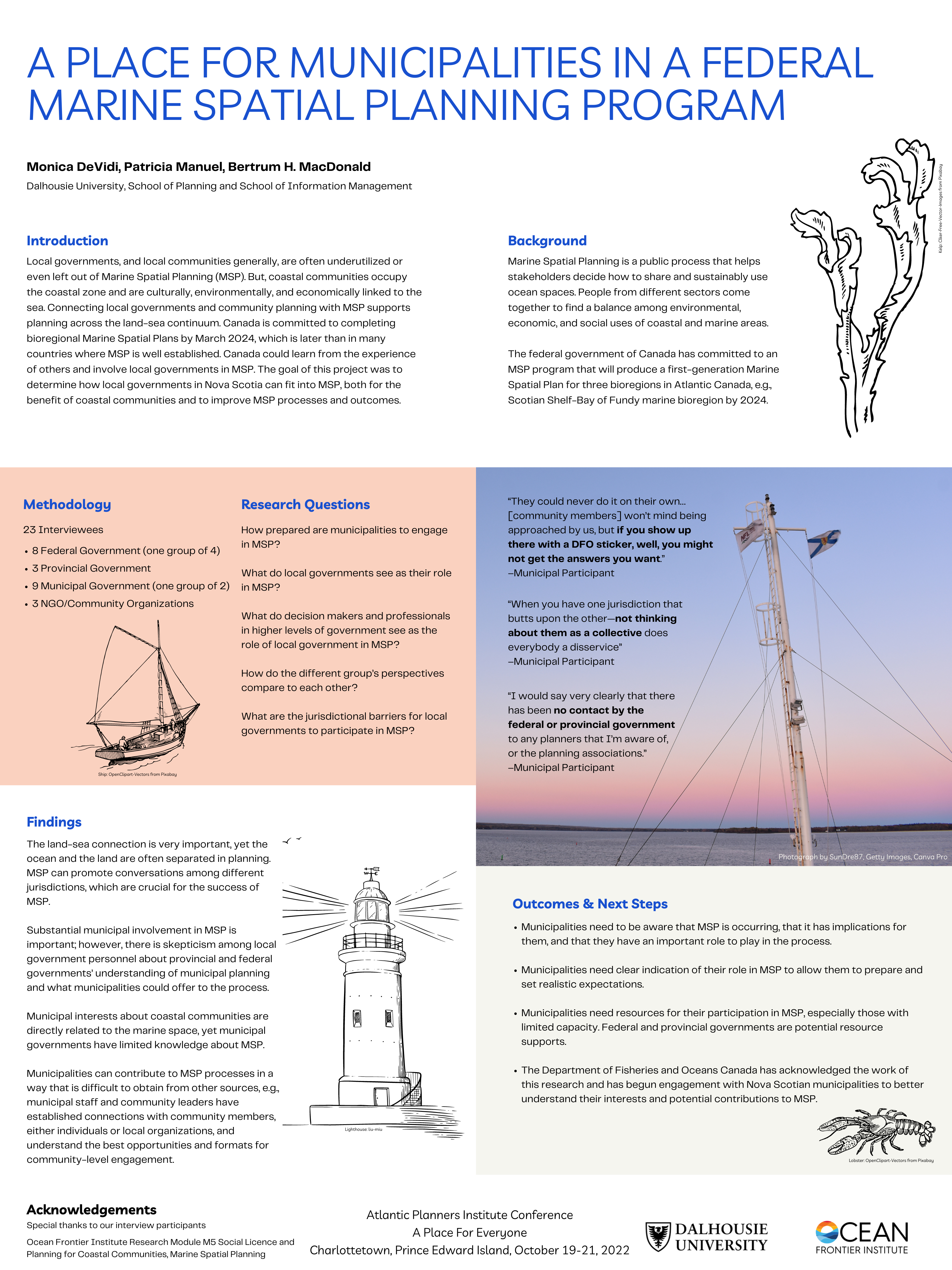
Monica DeVidi, a graduate of the Dalhousie Master of Planning program, and currently a researcher with BC Healthy Communities, presented the paper, “Role for municipalities in marine spatial planning: A case study of Nova Scotia” (co-authored with Patricia Manuel and Bertrum MacDonald). This paper was based on an examination of the role for Nova Scotian municipalities in MSP for the Scotian Shelf-Bay of Fundy marine planning bioregion. As the federal government does not have a direct relationship with municipalities, an explicit connection does not exist for coastal municipalities to participate in the federal MSP process. However, municipalities can provide local knowledge and planning protocols, including public participation, that could lend support for marine plans by people who will be most affected by the outcomes. Monica drew on the perspectives and experience identified in 23 interviews with representatives of municipal, provincial, and federal government departments and non-governmental organizations. While their views about the purpose and processes of MSP varied, all of the participants saw the need to obtain input from every level of government. The participants also suggested that municipalities had a limited knowledge about MSP and a weak understanding of the role they can play, as well as skepticism among municipal participants about what senior governments understand about their role in planning and what they could offer to the process. If the purpose of MSP is to facilitate sustainable, marine management while promoting a blue economy, coastal communities should be primary beneficiaries of a plan. The ocean and the land are not separate – coastal communities occupy the land-sea interface – yet, as many interviewees pointed out, the ocean and land are often separated in planning processes. Monica’s presentation concluded with consideration of how MSP in the Nova Scotia context can promote more opportunity for local government in marine sector decision-making that could lead to better marine plans with local relevance and connections across planning systems.
The questions and discussion with the audience demonstrated that land use and community planners could and should contribute to marine spatial planning in the region: as many pointed out, they are the spatial planning experts. While a few had some knowledge of the MSP initiative, obtained through a project conducted by Monica on behalf of DFO, most of these planners were hearing about it for the first time. In their opinion, their planning skills and community knowledge would be an asset. They noted that the marine atlas could be a useful tool and that the government should be publicizing this planning work and reaching out to engage communities. These planners welcomed marine planning and could see the connections with land planning in coastal regions, but also highlighted the jurisdictional confusion and arguments that seem to stymie efforts to coordinate planning in the coastal zone. Our session provided valuable information for these professionals who should know about this new spatial planning with its implications for their communities and who have the training, skills, and knowledge to contribute to it.
Conference Posters
“Towards Comprehensive Coastal and Marine Planning: A Comparison of Integrated Coastal Zone Management and Marine Spatial Planning.” Daniel Martinez Calderon, Bertrum H. MacDonald, and Patricia Manuel
“A Place for Municipalities in a Federal Marine Spatial Planning Program.” Monica DeVidi, Patricia Manuel, and Bertrum H. MacDonald
“Exploring the Position of Coastal Communities in Marine Spatial Planning: Bridging Land and Sea.” Bertrum H. MacDonald, Patricia Manuel, Monica DeVidi, Daniel Martinez Calderon, and Julia Szujo
Author: Patricia Manuel


